
Digitally Mapping Commercial Currents
Maritime Mobility, Vessel Technology, and U.S. Colonization of Puget Sound, 1851–1861
Abstract
In November 1851, Simpson P. Moses announced the arrival of American authority in Puget Sound, the inland sea at the heart of the Pacific Northwest, by opening a large leather-bound book and writing a series of notes across the top of its first two pages.
Nov. 15 1851. Brig George Emery. 178 59/95. Saucy, State of Maine, 1846. Coast license. James M. Bachelder. 8. Merchandise & Ballast. 14. San Francisco October 24, 1851. 8. San Francisco Nov. 19, 1851. Enoch S. Fowler. C. License. Piles, Shingles & Potatoes.1
These notes comprised the first of what would, over the next decade, amount to more than 4,500 entries in the ledger Moses carried. He entered Puget Sound as the inaugural U.S. Collector of Customs for the Puget Sound Customs District, which Congress had organized earlier that year. In a neat bureaucratic trick, Moses authorized his own arrival: The George Emery carried him from San Francisco to his posting of Olympia, a small American settlement at the head of Puget Sound. Until April 1861, Moses and his successors used this ledger to record a wealth of information about vessels entering and leaving the Puget Sound Customs District.
The 1850s were a pivotal decade for U.S. colonization of the Pacific Coast and Pacific Northwest. Even as the 1848 California gold rush sparked new transpacific migration and trade patterns, it also marked a moment when the United States began consolidating its territorial holdings to make the Pacific Coast more fully a part of the U.S. West.2 In the Pacific Northwest, growing numbers of American settlers and other non-natives combined with increasingly formalized U.S. territorial governance to constrain possibilities for indigenous autonomy.3 These changes often relied on what Anne Hyde terms the “scaffolding of American conquest—–railroads, armies, surveyors, reservations, censuses, and law.”4 Similar changes were roiling the wider Pacific Ocean, which Matt Matsuda argues was increasingly populated by “trans-local” places, specific local sites that came to host global connections.5 What did the “scaffolding of American conquest” look like in a coastal border region? How did Puget Sound become a trans-local place? And what role did steam propulsion play in these changes?
This ledger, as a collection of information registered by U.S. officials about local and global maritime voyages, can help to answer these questions. During spring 2019, I worked with two undergraduate research assistants to transcribe the ledger’s handwritten entries and cross-check the resulting data. (More information, including the data used to prepare this article, is available on the project website .) In this article, I use digital mapping and data visualization to reveal aggregate trends and interpret the ledger data. Scholars have long studied patterns of maritime mobility to understand larger historical trends, from Fernand Braudel’s work on the Mediterranean Sea, to Epeli Hauʻofa’s conceptualization of the island Pacific, to Ernesto Bassi’s investigation of the “lived geography” of the Caribbean Sea.6 The customshouses where this ledger was used were, by virtue of their function, trans-local places, connective nodes within global and local trade networks.7 By tracking individual vessels into and out of Puget Sound, the ledger makes it possible to examine, at a very fine resolution, the role of steam propulsion in American settlement of the coastal Pacific Northwest.
Steam power propelled Anglo-American colonization across both North America and the Pacific Ocean. Jay Sexton and Alicia Maggard argue that the United States and American settlers used steam technology to extend U.S. sovereignty over the North American West and into the Pacific.8 Frances Steel takes an oceanic view, arguing that white settlers in Australia, Canada, and the United States saw transpacific steamships as a connective technology advancing Anglo-American settler colonialism.9 Within the Pacific Northwest, Mary Catherine Greenfield argues that Anglo-Americans associated steam propulsion with racial superiority and colonial control.10 While these studies emphasize steam propulsion’s importance to different colonial projects, they tend to consider steam in isolation from other maritime technologies. But steam-powered vessels did not operate alone: They shared the waters with sailing vessels and human-powered watercraft like canoes and rowboats.11 Indeed, on the Pacific Coast, steam replaced sail as a primary method of propulsion slowly and haltingly, with merchant sailing vessels operating well into the twentieth century.12 By contextualizing steam propulsion within the larger domain of maritime mobility, this article complicates and refines our understanding of how vessel technology supported coastal colonization.
The ledger shows how the 1858 Fraser River gold rush catalyzed American settlement of the Pacific Northwest by making it easier for non-natives to reach Puget Sound and move within its waters. But while the gold rush changed travel patterns along the Pacific Coast and within the Pacific Northwest, these new patterns relied less on steam power and more on sailing vessels. The ledger affirms the gold rush’s impact, while also revealing the persistent importance of sail and the slow adoption of steam propulsion in the Pacific Northwest.
Puget Sound Customs District, Voyage Attributes Recorded and Date Spans Collected
| Voyage attribute | Dates collected |
|---|---|
| Vessel name | November 1851 - April 1861 |
| Vessel type | November 1851 - April 1861 |
| Tonnage | November 1851 - April 1861 |
| Place built | November 1851 - April 1857 |
| Year built | November 1851 - September 1853 |
| Papers or nationality | November 1851 - January 1859 (inconsistent after January 1859) |
| Date voyage began | November 1851 - September 1853 |
| Date of arrival or departure at Puget Sound | November 1851 - April 1861 |
| Port of origin (“where from” or “whence arrived”) | November 1851 - April 1861 |
| Destination port | November 1851 - April 1861 |
| Master’s name | November 1851 - April 1861 |
| Cargo | November 1851 - December 1858 |
| Number of crew | November 1851 - December 1858 |
| Number of passengers | November 1851 - December 1852 |
The ledger contains Customs officials’ records about vessels entering or leaving the Puget Sound Customs District between November 1851, when Moses arrived in Puget Sound, and April 1861, when his successors switched to a new ledger. Officials recorded data related to a vessel’s voyage, the vessel itself, and who and what was on board (as summarized in figure 1). Ledger entries became slightly less detailed in late 1858 and early 1859, likely an attempt to streamline data collection during the increase in vessel traffic associated with the Fraser River gold rush. Even so, officials recorded half of the attributes across the ledger’s full span, making it possible to analyze how these attributes changed over time.
Still, there are some structural limits to this data, resulting from the constrained view officials had of maritime traffic. The ledger did not capture information about indigenous maritime networks, which existed before American arrival and continued operating during and after this period.13 Second, unlike ship’s logbooks, the ledger did not record a vessel’s full itinerary, only its entrance into or exit from the customs district. Third, while the ledger recorded domestic voyages between U.S. customs districts (for example, from San Francisco to Puget Sound), it did not track voyages made entirely within the Puget Sound Customs District.
Even so, the ledger offers a much fuller portrait of Puget Sound maritime mobility than published sources. The Customs Service compiled only a few types of data in its annual reports, such as yearly totals of vessel arrivals and departures for each customs district.14 But these reports are missing information from Puget Sound for five of the nine full years covered by the ledger, precluding effective analysis.15 The ledger’s detailed vessel-by-vessel entries enable analysis at a much finer resolution—–by the day rather than the year–—than the Customs reports. Other possible sources, such as vessel arrivals and departures published by port-city newspapers, include data similar to that in the ledger. But while digitization initiatives have made such newspapers more accessible, compiling data from multiple issues—–hundreds per year, thousands per decade–—represents a significant barrier to research. The ledger, in contrast, offers a ready-made dataset.
Similar digital-humanities projects offer models for visualizing and mapping non-narrative maritime data. Scholars have built an atlas to reveal global geographic data contained in the Prize Papers, a collection of papers captured at sea by British ships during times of war between 1664 and 1817.16 Similarly, Benjamin Schmidt has mapped global voyages of U.S. ships between roughly 1785 and 1860, using data largely collected by Matthew Fontaine Maury in the years before the U.S. Civil War.17 But where these projects operate on a global scale and across multiple decades, this ledger’s tighter geographic coverage focuses our attention on the Pacific Northwest, and its rich detail enables us to track key changes over a relatively small period of time.
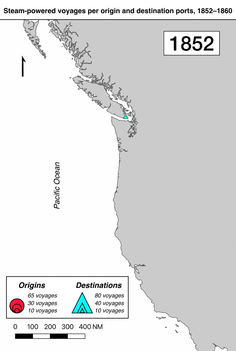
The Puget Sound Customs District ledger captures two overlapping geographies: of sail and of steam. In recording where different types of vessels originated and where they were bound, it describes patterns of human mobility in physical space. Mapping all the ledger’s unique origins and destinations, as shown in figure 2, illustrates how the Pacific Northwest was connected to points across the Pacific Ocean, and captures the extent of Puget Sound’s non-native shoreline settlements. In contrast, the map shown in figure 3 displays only those ports visited by steam-powered vessels. This smaller set of connections was entirely limited to the Pacific Coast and concentrated on commercial and administrative hubs, like San Francisco and Victoria. Even within Puget Sound, steam vessels called at only a subset of all ports. Figure 3 likely under-represents the extent of steam navigation within Puget Sound because Customs officials typically did not record a vessel’s intermediate stops between origin and destination. Even so, these maps show how non-natives in the Pacific Northwest initially used steam power for a limited set of local and regional links, not global connections.
While these maps effectively illustrate Puget Sound’s maritime links, they do not capture the relative importance of different ports. This gap becomes apparent when mapping how the number of voyages between different ports changed over time. Figure 4 animates a series of global maps, with the size of each port tied to the number of voyages for that year. A pattern emerges after 1856, as symbols for Victoria, San Francisco, and Puget Sound ports grow bigger and bigger.
The 1858 Fraser River gold rush brought thousands of people to the Pacific Northwest and, as shown in figure 5, led to a corresponding increase in travel and trade between Puget Sound, the British Northwest, and San Francisco. Between 1857 and 1858, voyages between Puget Sound and the British Northwest quadrupled; the overwhelming majority of traffic recorded in the ledger during 1858, 1859, and 1860 was to or from the British Northwest.
But steam vessels handled relatively little gold-rush traffic, as shown in figure 6. The gold rush created more traffic between Puget Sound and San Francisco, with voyages between these ports tripling between 1857 and 1858, even as voyages associated with other regions outside the Pacific Northwest stayed flat. Voyages by steam first surged, then receded. Steam vessels did not appear on the Puget Sound–San Francisco route until 1857 (when one steamship made one voyage), then made about half of all voyages between these ports in 1858 (41%) and 1859 (53%). In 1860, as the gold rush began to ebb, steamships fled the route, handling only 12% of traffic. Similarly, the percentage of steam-powered voyages between Puget Sound and the British Northwest fell to 14% in 1860, from an average of 35% in the years before the gold rush.
Plotting the ledger data reveals the individual voyages that sustained these connections, and highlights the role of smaller vessels in traffic associated with the Fraser River gold rush. Vessel tonnage and voyage frequency both suddenly and dramatically increased in early 1858.18 (Tonnage measures a vessel’s passenger and cargo capacity.) Before 1858, most vessels visiting Puget Sound were under 500 tons; after 1858, a procession of large sailing ships and steamships passed through Puget Sound. Many handled the new traffic between Puget Sound and San Francisco, with vessels over 700 tons consistently over-represented on this route during 1858, 1859, and 1860. More trips by larger vessels brought Puget Sound in closer contact with San Francisco.
But for every large ship inbound from San Francisco, dozens of smaller vessels also began swarming within Puget Sound. The Fraser River gold rush correlated with an increase in voyages by smaller sailing vessels. Surprisingly, despite the increase in trips by larger vessels, average tonnage decreased during this decade, falling slightly to 143.02 tons per vessel in 1860 from 147.69 tons per vessel in 1852. This change was particularly evident when I plotted the ledger data using a logarithmic scale, as shown in figure 7—a scale in which every tick mark on the vertical axis represents a ten-fold increase.19
The scatterplot is color-coded by vessel type. The different vessel types indicate differences in configuration and rigging. (A sloop, for example, has one mast, while a schooner has two.) This color-coding highlights several long horizontal bands, each representing trips by a single vessel. Because tonnage is a consistent and relatively particular characteristic, it can serve as a rough proxy for individual vessels. These tonnage bands highlight frequent, regular voyages. At first, steamboats stand out. The Hudson’s Bay Company steamboat Otter (144 tons) had an especially long term of service on Puget Sound, for example, with voyages from November 1853 to September 1860.
But plotting on a log scale shows how a swell of smaller vessels, especially schooners and sloops, created new tonnage bands after the gold rush began. Sloops are among the smallest and simplest sailing vessels, relatively cheap and easy to sail. Before 1858 the same four sloops (the Sarah Stone, the Helen, the Rob Roy, and the Colonel Ebey) handled all of the ledger’s sloop traffic. After 1858, officials recorded another fifty unique sloops entering or leaving Puget Sound, a twelve-fold increase. Unlike larger vessels, sloops stayed local; the ledger records sloops voyaging only between Puget Sound and the British Northwest. Since the ledger only recorded these vessels when they passed the customshouse, it likely under-represents their mobility within the Pacific Northwest. Sloops’ growing numbers made it easier for non-natives to travel the region’s waters.
The ledger captures how the Fraser River gold rush shaped Puget Sound into a trans-local place by strengthening its connections to San Francisco and catalyzing local vessel traffic. The gold rush altered the technological make-up of Puget Sound’s merchant marine, changing how non-natives circulated into and within Puget Sound. U.S. colonization of Puget Sound relied both on large vessels making long-distance voyages and on small vessels making shorter local and regional trips. Together, larger steamships and sailing vessels made possible regular voyages that increasingly linked Puget Sound with San Francisco, while a swarm of small sailing vessels drew ports within the Pacific Northwest closer together.
This project demonstrates the potential of digitally analyzing this type of raw data. The National Archives holds hundreds of similar ledgers, which offer equally fine-grained records for their respective customs districts. Transcribing other ledgers could expand this dataset’s chronological and geographic coverage, yielding additional insights about how maritime connections changed over time and enabling comparisons between different places. How did the types of vessels transiting Puget Sound change as the Fraser River gold rush ebbed, or after the transcontinental railroads arrived? Was steam technology distributed or adopted unevenly across the nineteenth-century United States? What did the transition from sail to steam look like in San Francisco, New Orleans, or Boston? These investigations would help us to better understand the maritime dimensions of U.S. territorial expansion and the ways steam technology shaped the nineteenth-century United States.
Bibliography
Bassi, Ernesto. An Aqueous Territory: Sailor Geographies and New Granada’s Transimperial Greater Caribbean World. Durham, NC: Duke University Press, 2016. https://doi.org/10.1215/9780822373735 .
Braudel, Fernand. The Mediterranean and the Mediterranean World in the Age of Philip II. Translated by Siân Reynolds. New York: Harper & Row, 1972.
Greenfield, Mary Catherine. “The Unending Conquest of the S.S. Beaver: Steam Power and the Myth of the White Anglo-Saxon Nation in the Nineteenth-Century Pacific Northwest.” Ph.D. diss., Yale University, 2016.
Harmon, Alexandra. Indians in the Making: Ethnic Relations and Indian Identities around Puget Sound. Berkeley, CA: University of California Press, 1998.
Hauʻofa, Epeli. “Our Sea of Islands.” The Contemporary Pacific 6, no. 1 (Spring 1994): 148–161.
Huber, Valeska. “Multiple Mobilities, Multiple Sovereignties, Multiple Speeds: Exploring Maritime Connections in the Age of Empire.” International Journal of Middle East Studies 48, no. 4 (November 2016): 763–766. https://doi.org/10.1017/S0020743816000908 .
Newell, Gordon, ed. The H. W. McCurdy Marine History of the Pacific Northwest. Seattle: Superior Publishing, 1966.
Hyde, Anne Farrar. Empires, Nations, and Families: A New History of the North American West, 1800–1860. New York: Ecco, 2012.
Igler, David. The Great Ocean: Pacific Worlds from Captain Cook to the Gold Rush. New York: Oxford University Press, 2013.
Land, Isaac. “The Urban Amphibious.” In The New Coastal History: Cultural and Environmental Perspectives from Scotland and Beyond, edited by David Worthington. Cham, Switzerland: Palgrave Macmillan, 2017. https://doi.org/10.1007/978-3-319-64090-7_2 .
Lutz, John. “Work, Sex, and Death on the Great Thoroughfare: Annual Migrations of ‘Canadian Indians’ to the American Pacific Northwest.” In Parallel Destinies: Canadian–American Relations West of Rockies, edited by John Findlay and Ken Coates, 80–103. Seattle: University of Washington Press, 2002.
Maggard, Alicia. “One Nation, Under Steam: Technopolitics, Steam Navigation, and the Rise of American Industrial Power.” Ph.D. diss., Brown University, 2019. https://doi.org/10.26300/065t-3028 .
Matsuda, Matt K. Pacific Worlds: A History of Seas, Peoples, and Cultures. New York: Cambridge University Press, 2012. https://doi.org/10.1017/CBO9781139034319 .
Prize Papers Online Atlas. https://prize-papers-atlas-online.brillonline.com .
“Registers of Entrances and Clearances of Vessels, Nov. 1851 - April 1861.” RG36, series 17, vol. 1. National Archives and Records Administration, Seattle.
Reid, Joshua. The Sea is My Country: The Maritime World of the Makahs, an Indigenous Borderlands People. New Haven: Yale University Press, 2015.
Schmidt, Benjamin. “Reading Digital Sources: A Case Study in Ship’s Logs.” Sapping Attention (blog). 15 November, 2012. http://sappingattention.blogspot.com/2012/11/reading-digital-sources-case-study-in.html .
Sexton, Jay. “Steam Transport, Sovereignty, and Empire in North America, circa 1850–1885.” Journal of the Civil War Era 7, no. 4 (December 2017): 620–647. https://doi.org/10.1353/cwe.2017.0085 .
Steel, Frances. “The ‘Missing Link’: Space, Race, and Transoceanic Ties in the Settler-Colonial Pacific.” Transfers 5, no. 3 (Winter 2015): 49–67. http://dx.doi.org/10.3167/TRANS.2015.050305 .
Steel, Frances. “Anglo-worlds in Transit: Connections and Frictions Across the Pacific.” Journal of Global History 11 (2016): 251–270. http://dx.doi.org/10.1017/S1740022816000085 .
United States Department of the Treasury. “Report of the Secretary of the Treasury, Transmitting a Report from the Register of the Treasury of the Commerce and Navigation of the United States.” 1852–1860.
Whaley, Gray. Oregon and the Collapse of Illahee: U.S. Empire and the Transformation of an Indigenous World, 1792–1859. Chapel Hill: University of North Carolina Press, 2010. https://doi.org/10.5149/9780807898314_whaley .
Notes
Reid, The Sea is My Country. Whaley, Oregon and the Collapse of Illahee. I use the term “non-native” throughout this article to refer collectively to non-indigenous settlers, colonists, migrants, and sailors who entered the Pacific Northwest during this period, voyaging there for different reasons and staying for different lengths of time.
Braudel, The Mediterranean; Hauʻofa, “Our Sea of Islands”; Bassi, An Aqueous Territory, 8.
Sexton, “Steam Transport”; Maggard, “One Nation, Under Steam.”
Steel, “The ‘Missing Link’”; Steel, “Anglo-worlds in Transit.”
Harmon, Indians in the Making; Lutz, “Work, Sex, and Death on the Great Thoroughfare”; Reid, The Sea is My Country.
U.S. Department of the Treasury, “Report of the Secretary of the Treasury.”
Annual totals for Puget Sound Customs District vessel arrivals and departures are missing from reports for the following fiscal years: 1852, 1853, 1854, 1855, and 1860. The first four reports omit the Puget Sound Customs District entirely; the 1860 report includes the district but lists no associated data.
A similar but smaller increase in vessel size and voyage frequency is visible in mid-1854, but this apparent increase in traffic is actually the result of improved data collection. In 1854, the Puget Sound customshouse moved from Olympia to Port Townsend, a point closer to the open Pacific Ocean where it was more convenient for vessels to stop.
Author
Sean Fraga,
USC–Mellon Humanities in a Digital World Program, University of Southern California, sfraga@usc.edu, 0000-0002-6804-4486