
A Tale of Three Valleys
Text Mining, Spatial Analysis, and the Contested Geographies of Colorado and New Mexico’s San Luis Valley
Abstract
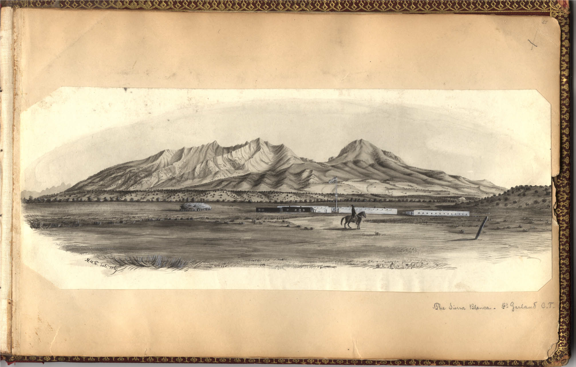
On a brisk October morning in 1868, William Gilpin and Ferdinand Hayden emerged from the mountain pass and gazed along the broad grassy valley toward the headwall of the Sierra Blanca Massif (see figure 1). Their arrival likely caused little commotion in Colorado and New Mexico’s San Luis Valley. The valley, like much of the Colorado and New Mexico territories, buzzed with excitement over rumors of a recently renewed Ute-American conflict and the final reports of a federal boundary survey at the Colorado-New Mexico border.1 Gilpin and Hayden, however, were in the region for different purposes. In just a few short weeks, Gilpin, a former Colorado Governor turned land speculator, and Hayden, a renowned federal geologist, intended to survey the Sangre de Cristo Land Grant, a one-million-acre parcel in the valley’s southeastern corner. Gilpin, who had recently acquired large swaths of the parcel, aimed to appraise, develop, and sell the grant with the help of English and American financiers.2 Upon their return from the surveying project, Hayden wrote to William Blackmore, Gilpin’s business partner and fellow stakeholder in the grant, to report that the San Luis Valley “could not have been more perfectly adapted to the wants of an agricultural region if it had been arranged by the hand of art.”3
But was the San Luis Valley such a paradise? Or was Gilpin and Hayden’s portrayal of the region more promotional act than truthful testimony?4 Gilpin and Hayden’s vision of the San Luis Valley was but the latest in a series of attempts to define, control, and profit from the valley’s material environment—a repetitive pattern that, as historian Patricia Nelson Limerick argues, is ubiquitous in American Western history.5 During the mid-nineteenth century, the San Luis Valley existed as a borderland region, a contested meeting ground between unique cultures and peoples who sought to harness the valley’s resources to their own ends and among whom Gilpin and Hayden were the newest arrivals.6 Throughout the 1850s, Capote and Muache Utes, Nuevomexicano farmers and sheepherders, and U.S. Army regulars all laid competing claims to the region’s future.7 Alongside Gilpin and Hayden, during the 1860s and 1870s, a growing tide of American and European migrants joined the existing population of Utes, Nuevomexicanos, and American soldiers in this contested borderland.8 When Americans flocked to the San Luis Valley in growing numbers, an alternative portrait of the region emerged alongside Gilpin, Hayden, and Blackmore’s promotions; an “imagined geography” largely produced in Colorado newspapers that represented the San Luis Valley as an obstacle to be overcome en route to the mines of the San Juan Country rather than as an agrarian paradise rife with potential.9
This essay leverages digital tools to place Gilpin and Hayden’s portrayal of the Sangre de Cristo Land Grant and the San Luis Valley alongside an alternative portrait of the region that developed in contemporary Colorado newspapers as Americans moved west into the basin. In doing so, it adds to the local body of scholarship on the San Luis Valley by revealing how distanced historical actors also laid claims to the region as they sought to promote the valley as an ideal and profitable route between the Colorado plains and the San Juan Country. I use Voyant Tools and Palladio to analyze a corpus of 256 Colorado newspaper articles published between 1862 and 1878, largely by newspapers located outside of the San Luis Valley whose reporters and contributors wrote to inform migrants and distant readers about the region.10 While a selection of 256 articles is a small corpus for digital analysis, it constitutes a surprisingly large source base for a historically remote location like the San Luis Valley. Applying digital methods to projects with small data offers a new avenue for regional approaches to borderlands history and the history of the American West. As a digital study in the contested nature of the San Luis Valley’s regional identity, this essay demonstrates that digital methods are well-suited to broaden the geographic scale of the stories we tell about borderland regions like the San Luis Valley—an approach that allows us to more fully consider the wide range of peoples who have laid claim to the borderlands of American Western history.
Though many aspects of Hayden and Gilpin’s promotional efforts failed to materialize in the Colorado press, the findings in Hayden’s published report were not entirely divorced from distanced perceptions of the San Luis Valley. Like the regional press, Hayden devoted parts of his report to the San Luis Valley’s road system, noting that “the roads travelled were firm and smooth.”11 According to Hayden, “the natural roads in this district [were] not surpassed for their excellence in any part of the world.”12 Americans outside the San Luis Valley shared Hayden’s preoccupation with road conditions in the Intermountain West and, between 1862 and 1878, the Colorado press discussed roads, distance, and mountain passes most frequently relative to other topics in articles associated with the San Luis Valley (Figure 3). Unfortunately for Hayden, Gilpin, and Blackmore, newspaper accounts of routes into the San Luis Valley rarely championed the valley’s potential for cultivation. Although references to stock-raising appear with some frequency (Hayden purported that the valley contained “excellent pasture”), outside observers were more likely to encounter newspaper accounts that discussed how they might reach the San Luis Valley but said little about what they might do once they arrived. Unlike Hayden, the regional news media did little to portray the San Luis Valley as “the most inviting and most promising district west of the Missouri River.”13
High-Frequency Topics Discussed in Coverage of the San Luis Valley (Excludes Place Names)
| Term | Frequency |
|---|---|
| Mile(s) | 194 |
| Road(s) | 163 |
| Pass(es) | 114 |
| Good | 86 |
| Stock | 86 |
| New | 84 |
| Mine(s) | 79 |
Colorado newspapers differed from Hayden and Gilpin in their interpretation of why Americans should travel over the region’s apparently impeccable thoroughfares. Whereas Hayden and Gilpin positioned the valley floor as a destination for eager settlers, newspapers were far more likely to identify the region as an obstacle that stood between American migrants and southwestern Colorado’s crown jewel: the San Juan Country. Following an initial gold rush in 1858, the San Juan Country garnered prospectors’ attention in the early 1860s and loomed large in public perceptions of the Colorado Territory. The San Juan mines, however, remained physically remote throughout the 1870s and most overland traffic to the region flowed through passes along the western edge of the San Luis Valley.14
For the unfamiliar migrant, knowledge of road and pass conditions was crucial to any attempt to tap the San Juan Country’s mineral wealth. By publishing details on routes to the San Juan Country, Colorado newspapers provided travelers with valuable geographic knowledge. Often, newspaper articles linked a road or pass into the eastern edge of San Luis Valley with a complimentary route leading out of the valley’s western side. For example, in an 1872 article appearing in Pueblo Colorado’s Colorado Daily Chieftain, a G.W.J. claimed to offer the “sound advice” that future travelers should restock their supplies in Pueblo before heading over the Sangre de Cristo Pass and across the valley. If they were lucky, G.W.J. noted, they “may possibly outfit in part” at Saguache or Conejos, two towns along the valley’s western edge frequented by travelers en route to the San Juan Mountains.15 Though brief, G.W.J.’s description of the valley suggested to travelers that Pueblo, Saguache, and Conejos were of some utility during the journey to the true objective of readers moving towards the San Luis Valley: the San Juan Country. In G.W.J.’s report, communities that lay in between Pueblo and the valley’s western markets, like Fort Garland, simply faded into the blank space of the press’s “imagined geography” of the San Luis Valley.16 When geographic knowledge like that offered by G.W.J. is visualized as a bubble map in Palladio, it becomes clear that aspiring prospectors and migrants who read Colorado newspapers received information that granted the mountain passes and supply points along the valley’s perimeter more geographic significance than the small communities spread across the valley’s interior, including those on the Sangre de Cristo Land Grant (see figure 4).
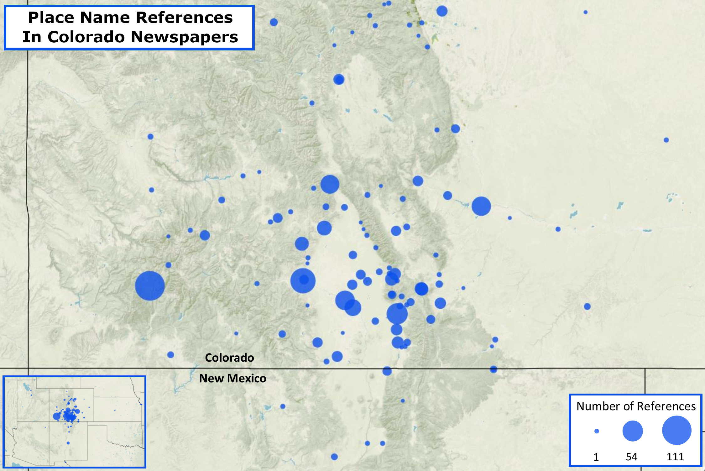
As newspapers directed new arrivals through the San Luis Valley and onwards to the San Juan Mountains, they provided readers with a geography of the San Luis Valley that privileged routes to the San Juan Country. In the text of Colorado newspaper articles, places along the valley’s edge appeared more frequently in association with the San Luis Valley than did settlements on the valley floor. Often, these locations were passes high in the Sangre de Cristo or Sierra Madre Mountains or westward towns like Del Norte and Saguache that offered trade goods and supplies for prospectors headed to the San Juan Country. By emphasizing mountain passes and markets along the route to the San Juan Country, the Colorado press attempted to reimagine the San Luis Valley as part of a new Western region—one with a geography defined by the movement of prospectors and minerals over the Rocky Mountains rather than by the priorities of land speculators or the valley’s Nuevomexicano and Indigenous residents.
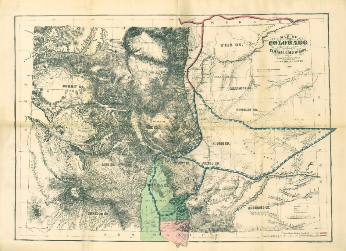
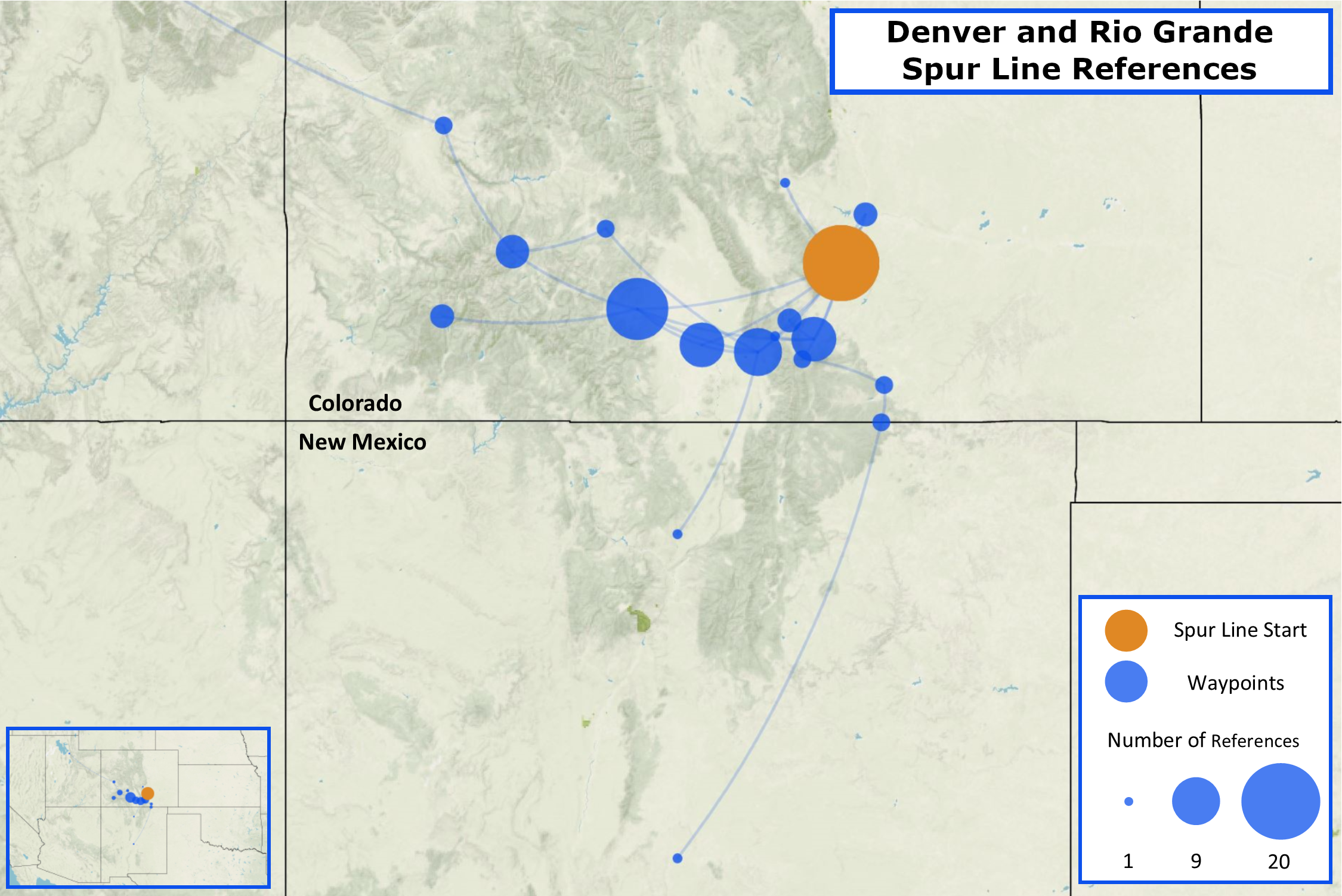
By the late 1870s, the physical route across the San Luis Valley became more linear as the Denver and Rio Grande (D&RG) railroad transformed roads into narrow gauge track when they constructed new lines to the San Juan Country. So too did the “imagined geography” of the region produced in Colorado newspapers.17 The D&RG, which eventually crossed the Sangre de Cristo Mountains and arrived in Alamosa, Colorado in 1878, was regularly covered by the regional press. With plans to push on towards Del Norte and the San Juan Country, the D&RG, as the Colorado Chieftain put it, had “come near to annihilating time and space” in the San Luis Valley.18 Unlike the Ebert’s “Map of Colorado Embracing the Central Gold Region” (seen in figure 2), which positioned the Sangre de Cristo Land Grant as the eventual destination of the D&RG (likely at the behest of Gilpin), press coverage of the D&RG instead portrayed timely access to the San Juan Country as the railroad’s primary objective. In covering the D&RG’s activity in the San Luis Valley, the regional press began associating the route through the San Luis Valley with existing and planned stops along the D&RG tracks. No longer would migrants need geographic knowledge of multiple routes into the valley. Instead, the public only required knowledge of places touched by D&RG locomotives (see figure 5).
Although mapping the place names that Colorado newspapers associated with the San Luis Valley populates the region’s northern half with place-based nodes, the San Luis Valley’s southern half was hardly devoid of human activity. Since the 1840s, Nuevomexicanos had occupied settlements in the valley’s southern end where they primarily herded sheep.19 Ute bands had also resided in the San Luis Valley for centuries and, in the 1850s and 1860s, the southern San Luis Valley operated as a focal point of Ute-American military conflicts and diplomatic relations.20 Within the selected corpus of newspapers, Ute bands and Nuevomexicanos appear occasionally, receiving forty-three and thirty-four respective mentions. In contrast to more frequent references to the San Luis Valley’s physical landscape, including to distance, movement, and land-use practices (see figure 3), Utes and Nuevomexicanos hardly received attribution equal to their population size or history of land tenure in the region. Newspaper articles discussing Ute bands are also skewed towards the earlier temporal bounds of the corpus, a pattern that likely reflected a regional preoccupation with the treaty-making process in the 1860s.21 The relative absence of Nuevomexicanos in textual descriptions of the San Luis Valley, however, is far more surprising given that Nuevomexicano colonists had moved into the valley’s southern end in the 1840s and, by the 1880s, comprised a sizeable majority of the region’s population as well as an important voting bloc in territorial elections.22 In Colorado, where most of the San Luis Valley lies, 8,484 of the valley’s 10,457 Coloradans lived in the overwhelmingly Nuevomexicano counties of Conejos and Costilla along the Colorado-New Mexico border in 1880.23 Even Hayden, in his 1868 report on the San Luis Valley and the Sangre de Cristo Land Grant, noted the presence of Nuevomexicano farmers and shepherds in the valley’s southern half.24 Though Nuevomexicanos played a significant role in the region’s mid-nineteenth-century history, the “imagined geography” forwarded by the Colorado press reveals how distanced observers readily erased the existence of communities who presence was either insignificant to or, in the case of Ute bands, incompatible with many Americans’ vision for the San Luis Valley’s future.25
This spatial disparity, between the northward geography forwarded by the Colorado press and the southerly distribution of valley populations, suggests that multiple, distinct San Luis Valleys existed in the late-nineteenth century. The first was the valley toured by Hayden and Gilpin and populated by Nuevomexicano settlers and Ute bands. The second emerged in the public consciousness and characterized the San Luis Valley by the quickest route across the basin and into the San Juan Country. The third, an agrarian “promised land,” existed only in the minds of a select few among the area’s travelers and residents—a group interested in portraying the region as ripe not only for settlement, but for a white settler utopia.26 Together, these divergent geographic identities reveal that the San Luis Valley was hardly remote and unknown to migrants and distanced observers. Rather, the valley remained a contested space throughout the mid-nineteenth century; one whose identity shaped how people moved through, experienced, and understood the southern Colorado landscape.
Throughout the 1860s and 1870s, differing individuals, communities, and corporate interests attached distinct identities to the San Luis Valley.27 Yet existing studies of the region thus far have not attempted to overlay these contested geographies with one another for two primary reasons: (1) historians of the San Luis Valley have generally privileged local narratives over regional or national ones and (2) until recently, the region’s late-nineteenth century history has often remained distant from historical evidence that originated and resided outside the valley.28 By using Palladio to visualize how the San Luis Valley emerged in newspaper accounts primarily from outside the region and considering those accounts and their associated geography as representative of how distanced readers understood the San Luis Valley’s cultural and physical geography in the 1860s and 1870s, this article demonstrates that digital methods are well-positioned to begin addressing these gaps in the region’s historiography.
This paper also holds implications for the use of digital tools in studies of other remote borderland regions. Although Daniel Cohen has argued that “it is now quite clear that historians will have to grapple with abundance, not scarcity” when working with a constantly expanding base of digitized sources, borderlands historians often confront the opposite: we regularly deal with scarcity in the places we explore through historical inquiry.29 This paper, however, suggests that the common paucity of digitized materials from historically remote places should not keep digital tools at bay in borderlands studies. Instead, borderlands scholars should leverage existing tools to redirect distanced sources towards remote places, as this paper attempts to do with Voyant Tools and Palladio. In doing so, we may find that digital tools can add depth to local stories while placing borderlands into narrative association with regional, national, and even continental histories.30 Moreover, by applying digital tools to places without readily available, massive datasets, we may also further the central goal of borderlands scholarship: leveraging stories from exciting, unique, and often unpredictable places to valuably complicate our understanding of regional, national, and global histories.
Newspaper Corpus
Boulder County News, (Boulder, Colorado)
Colorado Chieftain (Pueblo, Colorado)
Colorado Miner (Georgetown, Colorado)
Colorado Springs Gazette (Colorado Springs, Colorado)
Colorado Transcript (Golden City, Colorado)
Daily Commonwealth (Denver, Colorado)
Denver Daily Times (Denver, Colorado)
Daily Miners’ Register (Central City, Colorado)
Denver Tribune (Denver, Colorado)
Las Animas Leader (Las Animas, Colorado)
Ouray Times (Ouray, Colorado)
Daily Rocky Mountain News (Denver, Colorado)
Saguache Chronicle (Saguache, Colorado)
Silver World (Lake City, Colorado)
Bibliography
Andrews, Thomas. “Tata Atanasio Trujillo’s Unlikely Tale of Utes, Nuevomexicanos, and the Settling of Colorado’s San Luis Valley.” New Mexico Historical Review 75, no. 1 (2000): 4–41.
Aron, Stephen. American Confluence: The Missouri Frontier From Borderland to Border State. Bloomington: Indiana University Press, 2006.
Bartlett, Richard. Great Surveys of the American West. Norman: University of Oklahoma Press, 1962.
Blackhawk, Ned. Violence Over the Land: Indians and Empires in the Early American West. Cambridge: Harvard University Press, 2006.
Blackmore, William. Colorado: Its Resources, Parks, and Prospects as a New Field for Emigration; With an Account of the Trenchara and Costilla Estates, in the San Luis Park. London: Sampson Low, Son, and Marston, 1869. https://mountainscholar.org/handle/10217/35691 .
Blevins, Cameron. “Space, Nation, and the Triumph of Region: A View from the World of Houston.” Journal of American History 101, no. 1 (June 2014): 122–47. https://doi.org/10.1093%2Fjahist%2Fjau184 .
Brayer, Herbert O. William Blackmore: The Spanish-Mexican Land Grants of New Mexico and Colorado: 1863–1878. Denver: Bradford-Robinson, 1949.
Cassidy, James. Ferdinand V. Hayden: Entrepreneur of Science. Lincoln: University of Nebraska Press, 2000.
Cohen, Daniel J., Michael Frisch, Patrick Gallagher, Steven Mintz, Kirsten Sword, Amy Murrell Taylor, William G. Thomas, III, and William J. Turkel. “Interchange: The Promise of Digital History.” Journal of American History 95, no. 2 (September 2008): 452–91. https://doi.org/10.2307/25095630 .
Deibert, Jack E. and Brent H. Breithaupt. Tracks, Trails & Thieves: The Adventures, Discoveries, and Historical Significance of Ferdinand V. Hayden’s 1868 Geological Survey of Wyoming and Adjacent Territories. Boulder: Geological Society of America, 2016.
Department of the Interior, Bureau of the Census. Cartographic Boundary Files. 2017. https://www.census.gov/geographies/mapping-files/time-series/geo/carto-boundary-file.2017.html .
Department of the Interior, Bureau of the Census. Tenth Census of the United States, Volume I, Statistics of the Population of the United States. Washington, D.C.: Government Printing Office, 1883.
Department of the Interior, Geological Survey. “Digital Archive: Previously Unpublished Sketches by Henry W. Elliot united with the Preliminary Field Report of the United States Geological Survey of Colorado and New Mexico, 1869, by. F. V. Hayden.” Edited by Kevin C. McKinney. https://pubs.usgs.gov/of/2003/0384/report.pdf .
Ebert, Frederick J. “Map of Colorado Embracing the Central Gold Region.” 1869. Colorado Agriculture Bibliography, Water Resources Archive, Colorado State University, Fort Collins, Colorado. https://mountainscholar.org/handle/10217/35691 .
Edelstein, Dan, Nicole Coleman, Ethan Jewett, Eliza Wells, Giorgio Caviglia, and Mark Braude. Palladio. Release 1.1. Stanford Humanities and Design Lab, 2015. http://hdlab.stanford.edu/palladio/ .
Foster, Mike. Strange Genius: The Life of Ferdinand Hayden. Niwot, CO: Roberts Rinehart Publishers, 1995.
Geary, Michael. Sea of Sand: A History of Great Sand Dunes National Park and Preserve. Norman: University of Oklahoma Press, 2016.
Goetzmann, William. Exploration and Empire: The Explorer and the Scientist in the Winning of the West. Austin: Texas Historical Association, 1966.
Gonzales, Nicki. “‘Yo Soy Loco Por Esa Sierra’: The History of Land Rights Activism in San Luis Colorado, 1863–2002.” PhD diss., University of Colorado at Boulder, 2007.
Hämäläinen, Pekka and Samuel Truett. “On Borderlands.” Journal of American History 98, no. 2 (September 2011): 338–61. https://doi.org/10.1093%2Fjahist%2Fjar259 .
Hamber, Anthony. Collecting the American West: The Rise and Fall of William Blackmore. Salisbury, UK: Hobnob Press, 2010.
Kindquist, Cathy. “Communication in the Colorado High Country.” In The Mountainous West: Explorations in Historical Geography, edited by William Wyckoff and Lary M. Dilsaver, 114–37. Lincoln: University of Nebraska Press, 1995.
Limerick, Patricia Nelson. The Legacy of Conquest: The Unbroken Past of the American West. New York: W. W. Norton & Company, 1987.
Mondragon-Valdez, Maria. “Challenging Domination: Local Resistance on the Sangre de Cristo Land Grant.” PhD diss., University of New Mexico, 2006.
Sánchez, Virginia. Pleas and Petitions: Hispanic Culture and Legislative Conflict in Territorial Colorado. Boulder: University Press of Colorado, 2020.
Schulten, Susan. Mapping the Nation: History and Cartography in Nineteenth-Century America. Chicago: University of Chicago Press, 2012.
Simmons, Virginia McConnell. The San Luis Valley: Land of the Six-Armed Cross. 2nd ed. Niwot, CO: University Press of Colorado, 1999.
Simmons, Virginia McConnell. The Ute Indians of Utah, Colorado, and New Mexico. Boulder: University of Colorado Press, 2001.
Sinclair, Stéfan and Geoffrey Rockwell. Voyant Tools. 2016. http://voyant-tools.org/ .
Steiner, Michael and David Wrobel. “Many Wests: Discovering a Dynamic Western Regionalism.” In Many Wests: Place, Culture, and Regional Identity, edited by David Wrobel and Michael Steiner, 1–30. Lawrence: University Press of Kansas, 1997.
White, Richard. “What is Spatial History?” Stanford Spatial History Lab, Working Paper. February 1, 2010. https://web.stanford.edu/group/spatialhistory/cgi-bin/site/pub.php?id=29 .
William Blackmore Land Records, 1856–1870. New Mexico State Records Center and Archives, Santa Fe, New Mexico.
Wrobel, David. Promised Lands: Promotion, Memory, and the Creation of the American West. Lawrence: University of Kansas Press, 2002.
Notes
The author would like to thank Dr. Leisl Carr Childers, the anonymous peer reviewers, and the editorial staff at Current Research in Digital History for their helpful comments and feedback in preparing this manuscript.
“The Utes,” Daily Rocky Mountain News (Denver, Colorado), October 10, 1868; “The Southern Boundary,” Daily Rocky Mountain News, October 24, 1868.
On Gilpin, Blackmore, and Hayden’s efforts on the Sangre de Cristo Land Grant, see Brayer, William Blackmore. On Blackmore, see also, Hamber, Collecting the American West. On Hayden, see Foster, Strange Genius; Cassidy, Ferdinand V. Hayden. On the Hayden Survey, see Bartlett, Great Surveys of the American West; Goetzmann, Exploration and Empire, 489–529. On the circumstances leading to Hayden’s hiring by Blackmore, see Deibert and Breithaupt, Tracks, Trails & Thieves, 58–68.
Ferdinand V. Hayden, “Report of Professor F. V. Hayden” in Colorado, William Blackmore, 197. Blackmore also advertised the grant’s material environment in “Southern Colorado and Its Resources: A New Field for English Emigrants,” William Blackmore Land Records.
David Wrobel has referred these promotional landscapes as the “promised lands” of the American West. See Wrobel, Promised Lands.
Gilpin’s attempt to portray the Sangre de Cristo Land Grant as ripe for white settlement despite the presence of Nuevomexicanos and Utes in the region reflects Limerick’s insight that “Western history has been an ongoing competition for legitimacy—for the right to claim for oneself and sometimes for one group the status of legitimate beneficiary of Western resources.” See Limerick, The Legacy of Conquest, 27.
In positioning the San Luis Valley as a borderland, I draw here on Stephen Aron’s concept of a “confluence region,” a framework that positions places like the Missouri Valley borderland, which Aron studied, and the San Luis Valley as contested spaces of interaction and transformation between diverse groups of people. See Aron, American Confluence, xiii-xxi.
The San Luis Valley’s rich nineteenth century history has been explored in Brayer, William Blackmore; Simmons, The San Luis Valley; Mondragon Valdez, “Challenging Domination”; Gonzales, “‘Yo Soy Loco Por Esa Sierra.’” On Utes in the San Luis Valley, see Simmons, The Ute Indians of Utah, Colorado, and New Mexico; Andrews, “Tata Atanasio Trujillo’s Unlikely Tale,” 4–41; see also Blackhawk, Violence Over the Land.
American and European migrations to the valley, especially its northern portion, receive greater treatment in Geary, Sea of Sand.
Cameron Blevins employs the term “imagined geography” in his study of the Houston Daily Post between 1894 and 1901. Like Blevins, this study treats the Colorado newspapers’ “imagined geography” of the San Luis Valley as “an active process of social construction rather than a passive reflection of the world.” As Blevins aptly puts it, “newspapers print, and thereby privilege, certain places over others,” an argument that holds true both in turn-of-the-century Houston, as Blevins shows, and in the mid-nineteenth-century San Luis Valley. See Blevins, “Space, Nation, and the Triumph of Region,” 124. As Susan Schulten has shown, Gilpin was well-versed in using maps like the one produced by Ebert as well as other reports to promote settlement of the American Western interior by the time he and Hayden travelled across the Sangre de Cristo Land Grant. See Schulten, Mapping the Nation, 112–5; Ebert, “Map of Colorado Embracing the Central Gold Region.”
The act of reporting on the San Luis Valley was an exercise in what Richard White describes as “spatial representation,” which White defines as “an attempt to conceive in order to shape what is lived and perceived.” Through digital methods, this essay captures both the characteristics and geographic extent of this act of spatial representation. See White, “What is Spatial History?” Selected articles contain at least one use of “San Luis Valley,” were published by outlets located in the Colorado Territory, and were retrieved through the Colorado Historic Newspapers Collection . Other than the 14 articles in the corpus published by the Saguache Chronicle, all newspaper articles originated outside the San Luis Valley. Consult bibliography for full list of newspapers used in the corpus.
Kindquist, “Communication in the Colorado High Country,” 114–37.
G.W.J., “Interesting Sketch of the San Juan Mines—Sound Advice to Par es [sic] Who Propose to Visit that Region,” Colorado Daily Chieftain, May 9, 1872.
Manifold, “From Del Norte,” Colorado Daily Chieftain (Pueblo, Colorado), July 8, 1877.
On early Nuevomexicano history in the San Luis Valley, readers should consult Simmons, The San Luis Valley; Mondragon-Valdez, “Challenging Domination”; and Gonzalez, “Yo Soy Loco Por Esa Sierra.”
On Ute-Nuevomexicano relations in the San Luis Valley, see Andrews, “Tata Atanasio Trujillo’s Unlikely Tale,” 4–41. On treaties see, for example, “Indian Treaties,” Daily Rocky Mountain News, September 11, 1863; and “Indian Affairs,” Daily Rocky Mountain News, February 20, 1864.
On Nuevomexicano activity in elections, see, for example, Lafayette Head, “Important from Conejos,” Daily Rocky Mountain News, November 14, 1865; and Chaffee, “Election Returns,” Daily Rocky Mountain News, September 17, 1870.
A small portion of Taos County, New Mexico also lies in the San Luis Valley and the small, San Luis Valley communities that added to the county’s 11,029 residents were similarly Nuevomexicano in demographic character. See Department of the Interior, Bureau of the Census, Tenth Census of the United States, 52–53, 72.
Wrobel, Promised Lands; for an example of promoting white settlement in the San Luis Valley, see Blackmore, “Southern Colorado and Its Resources: A New Field for English Emigrants.”
Wrobel and Michael Steiner have argued that “at certain points in their personal and collective histories, Americans have been roused to a more vivid appreciation of place, creating historical rhythms in regional consciousness.” Their point is appreciably visible in the mid-nineteenth-century San Luis Valley, where white Americans, Nuevomexicanos (many of whom were American citizens), and Utes all attempted to shape a regional consciousness. In effect, the San Luis Valley’s history confirms not only that, as Wrobel and Steiner note, the American West was “really many Wests,” but, in the San Luis Valley at least, the American West names a space where multiple regional identities could exist simultaneously, even in opposition to one another. See Steiner and Wrobel, “Many Wests,” 7–9.
Recent works by Michael Geary (2016) and Virginia Sánchez (2020) suggest a growing interest in linking the San Luis Valley to a broader regional and national context. See Geary, Sea of Sand; Sánchez, Pleas and Petitions.
Historians Pekka Hämäläinen and Samuel Truett argue that the difficulty scholars currently have with pushing borderland histories beyond local context and significance is the core problem facing borderlands history. See Hämäläinen and Truett, “On Borderlands,” 338–61.
Appendices
Author
Jacob Swisher,
Department of History, University of Notre Dame, jswisher@nd.edu, 0000-0003-2270-4933